DMV releases crash map
Published 9:43 am Wednesday, August 9, 2017
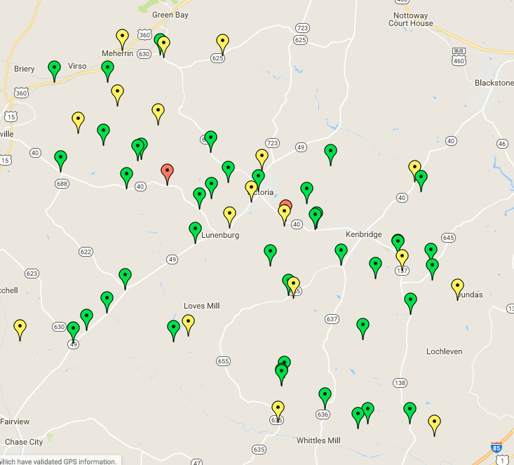
- According to the most recent data from the Virginia Department of Motor Vehicles, so far in 2017 there have been 61 vehicle accidents in Lunenburg County. The markers on the map note where the accidents have occurred. Red markers indicate crashes resulting in a fatality, green markers indicate property damage and yellow indicate crashes resulting in injury. Only two of the reported accidents have seen fatalities.
There have been 61 vehicle accidents in Lunenburg County since January, according to a new crash-tracking tool from the Virginia Department of Motor Vehicles (DMV).
According to the data, two accidents have resulted in fatalities, 18 crashes have resulted in injuries and 41 crashes resulted in property damage.
Nine of the accidents were alcohol-related, nine involved drivers between the ages 15-20 and 19 were speed related.
None of the accidents involved texting or cell phone use. Seven accidents occurred on both Oral Oaks Road and Courthouse Road — more than any other road in the county.
Traffic crash data information has been made more accessible for Virginians interested in gaining a better understanding of crashes occurring in their localities due in part to the new interactive crash locations map, according to a DMV press release.
According to DMV spokeswoman Brandy Brubaker, information on the map’s state of current information is dependent on law enforcement agencies from across the state.
“We get our information from law enforcement departments all over the state, so when we get the report from them it’s entered into our system,” Brubaker said. “…Sometimes there’s a lag behind for some of the reports though because maybe an officer is still investigating or hasn’t come back on duty to complete the report and that, in that case, we like to say that 2017 statistics are preliminary until we close out the year.“
Brubaker said the DMV has given the public access to the Traffic Records Electronic Data System (TREDS) since Aug. 2011.
“DMV is Virginia’s repository for Virginia crash reports and I don’t think a lot of people realize that,” Brubaker said. “Like I said, all the departments from the state send their crash reports to us, so we have all this data available so we’re like you know how’s it going to help anybody if it’s not shared with the public.”
She said that Virginia is a part of the Toward Zero Deaths movement, which is a national campaign to continually reduce crash deaths until they no longer occur.
“Education is a huge part of that,” Brubaker said. “Many crashes are completely preventable, so drivers having the education and the awareness of highway safety issues in the area or just in general, wearing seatbelts, not drinking and driving, not speeding, not driving distracted — these things can help reduce crash numbers and safe lives so we wanted to make that information accessible to Virginians.”
She said the map allows people see where crashes are occurring most in their neighborhoods and to filter that down even more to see what factors are causing the crashes.
According to the press release, in addition to the Crash Locations Map, DMV also hosts interactive features that allow users to create a Crash Data Report or explore a map of High Crash Locations, called clusters. No personal driver information is published.
The Crash Locations Map can be accessed at https://www.treds.virginia.gov/Mapping/Map/CrashesByJurisdiction.