Weather update: 8-16 inches possible for region
Published 6:39 am Sunday, December 9, 2018
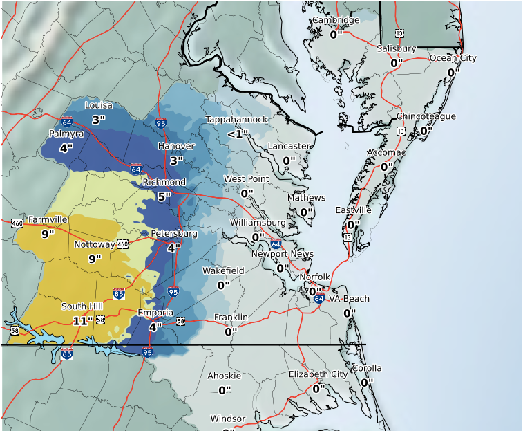
- Lunenburg, according to a weather map from the NWS, could receive approximately 9-11 inches of snow.
The National Weather Service (NWS) in Wakefield has issued a winter storm warning for Lunenburg County. Total snow accumulations are ranging from 4-10 inches, with some areas having the potential to see higher snowfall levels.
“Wet snow, which could be heavy at times especially during the day today,” documentation from the NWS cited Sunday morning. “The snow may mix with sleet or rain especially near the Virginia/North Carolina border and near I-95. Total snow accumulations of 4 to 10 inches expected with locally higher amounts possible. In addition, some light icing is possible this evening, as temperatures drop back below freezing. Temperatures will warm into the lower to mid 30s by this
afternoon.”
A winter storm warning, according to the NWS, means significant amounts of snow, sleet and ice would be present that makes travel highly hazardous or impossible. The warning is in effect until 4 a.m. Monday.
Snowfall is expected Sunday with periods of heavy snowfall possible. Chance of precipitation is 100 percent. Total daytime snow accumulation of 7 to 11 inches possible.
Going into Sunday night, snow, possibly mixing with rain is expected after 1 a.m., then gradually ending. Low around 27. North wind 10 to 15 miles per hour (mph), with gusts as high as 23 mph. Chance of precipitation is 80 percent. New snow accumulation of 1 to 3 inches possible.
The NWS cautioned that the snow could stick to tree branches, risking the potential for power outages.