Flash flood watch, tornado watch, wind advisory remain in effect in region
Published 10:47 am Thursday, October 11, 2018
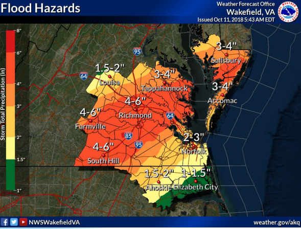
- NATIONAL WEATHER SERVICE Pictured is a graphic depicting flood hazards in the region. The Farmville region is expected to get anywhere between 3-6 inches between Thursday and Friday.
The National Weather Service (NWS) is cautioning residents as rainfall, winds and the potential for tornados is expected in the region Thursday into Friday morning.
A flash flood watch remains in effect for the county between Thursday morning and Friday morning where between 3 to 6 inches of watch could be expected for the region due to the effects of Tropical Storm Michael.
A tornado has been advised for Lunenburg and surrounding counties until 9 p.m. Thursday.
A wind advisory has been put in effect in Lunenburg County that begins 6 p.m. Thursday and ends Friday at noon.
Winds in the region are forecast to move from “east to southeast 20 to 30 (miles per hour) mph late this afternoon and early evening, becoming north to northwest 25 to 35 mph late tonight into early Friday morning,” the advisory from the NWS cited. “Wind gusts up to 50 mph are possible late tonight and overnight.”
Impacts, according to the advisory, may cause downed trees and isolated power outages, particularly in combination with heavy rainfall.
In the event of power outages, contact Dominion Energy at 866-366-4357 or Southside Electric Cooperative at 1-866-878-5514.
In the event that assistance from area first responders is needed to remove fallen trees, fire-related or medical emergencies, contact Victoria Fire & Rescue at (434) 696-2605, Kenbridge Fire Department at (434) 696-3131 and Kenbridge Emergency Squad at (434) 676-4848.
To learn how to build an emergency kit with items that include having one gallon a day for each member of the household, at least a three-day supply of non-perishable food, a battery-powered or hand crank radio and a NOAA Weather Radio with tone alert, a flashlight and first aid kit, visit www.ready.gov/build-a-kit.
Do not drive through or approach flooded areas.